


1. OPERATIONAL OVERVIEW
1-5
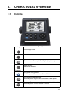
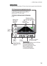
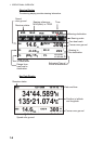
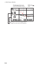
Highway Display
The highway display provides a 3-D view of own boat’s progress toward destination.
Bearing from
own boat to
destination
waypoint
Speed
over
ground
Course
over
ground
Digital XTE indication
(in nautical miles)
Range from own
boat to destination
waypoint
Own boat mark
The boat mark displays course as follows:
When no waypoint is set;
The mode is North-up and
the arrow shows boat’s course.
When a waypoint is set;
The arrow shows boat’s
course towards destination.
Direction to steer
(to return to course)
Current
position
299
166
0.46
14.6
N
E
Destination
waypoint name
XTE (Cross-track error) scale and arrow mark
Arrow shifts with boat’s XTE. When the arrow
is aligned with the center line the boat is on
course. The arrow blinks if boat’s XTE is
greater than XTE scale range.
“N (North)” is displayed, instead of the arrow,
at the center of the scale when no destination
is set.
: Steer right.
: Steer left.