


AgGPS 332 GPS Receiver User Guide 9
Overview 2
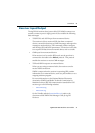
2.4 GPS Positioning Methods
GPS positioning systems are used in different ways to provide different
levels of accuracy. Accuracy is measured in absolute terms (you know
exactly where you are in a fixed reference frame).
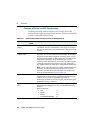
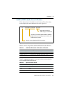
Table 2.1 summarizes the GPS positioning methods. Imperial units in
this table are rounded to two decimal places. The values shown are
2sigma.
For more information about each positioning method, see below.
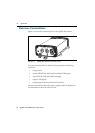
24.1 RTK GPS positioning
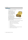
The AgGPS 332 receiver uses the RTK positioning method to achieve
centimeter-level accuracy. To use the RTK method, you must first set
up a base station. The base station uses a radio link to broadcast RTK
corrections to one or more rover receivers. The AgGPS 332 receiver is a
rover receiver, so another compatible receiver, such as a Trimble
MS750
™
or AgGPS 214 GPS receiver, must be used as the base station.
Table 2.1 Absolute accuracy of GPS positioning method
GPS positioning
method
Corrections used Approximate absolute accuracy
Real-Time Kinematic
(RTK) GPS
Trimble CMR
corrections broadcast
by a local base station
2.5 cm (0.98 in) + 2 ppm horizontal accuracy,
3.7 cm (1.46 in) + 2 ppm vertical accuracy
OmniSTAR HP
Differential GPS
OmniSTAR HP 10 cm (3.94 in) after the signal has fully
converged
1
1
Convergence time can vary, depending on the environment. Time to the first fix (submeter accuracy) is
typically <30 seconds; time to the first high accuracy fix (<10 cm accuracy) is typically <30 minutes.
OmniSTAR XP
Differential GPS
20 cm (7.87 in) after the signal has fully
Differential GPS converged
Satellite Differential GPS OmniSTAR VBS 78 cm (30.71 in)
Radio Beacon Coast Guard radio
beacon towers
.4 inch through 12 inch
(10 cm through 30 cm) RMS 15 min
Satellite Differential GPS WAAS/EGNOS 95 cm (37.40 in)