


29
iCN 530 | User Manual
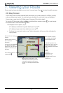
7. Viewing your Route
Once a route has been calculated, you can view it in several ways. Press to cycle through the screens.
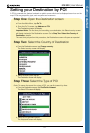
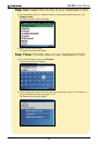
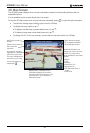
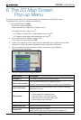
2D Map Screen
The 2D Map screen is always oriented North and shows your current position (if a GPS fix is active)
and surrounding street names. If a route has been calculated, the route and turns are highlighted.
You can plan a route from the 2D Map screen. See page 23 for further details.
To view the 2D Map screen, either tap Map on the Main Menu screen or press to cycle through
the screens when a route has been calculated.
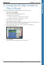
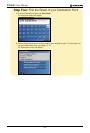
Additional information can
display here. Tap to scroll the
options. You must have a
route calculated to view these
options:
• Speed
• Time
• Heading
• Distance to Turn
• Distance to Go
• ETA (Estimated Time of
Arrival)
• Time to Go
Your next turn is highlighted
in a different colour from
future turns. The colour will
depend on the theme you
are using.
Your current position is
marked with .
North-oriented compass.
Tap to display the Satellite
Signal Strengths screen.
Direction of the next turn.
Tap to hear next
instruction.
Name of the next
location.
Displays either a description of the
information in the bottom right hand
corner of the screen or your current
location. Tap to display the Main Menu
screen.
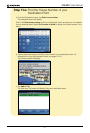
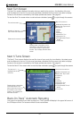
• To display the zoom options, tap .
• To display a smaller area in greater detail (zoom in), tap .
• To display a larger area in less detail (zoom out), tap .
• To display the cross-hairs, tap the map. Tap the intersection of the cross-hairs to display the
Pop-up menu.