


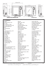

TRACKER 5505/5505i/5605 Installation and Operation Manual
65
NAVMAN
Attention Area - An important area on a chart,
such as a restricted anchorage or a shallow area
(see section 14-2).
Bathymetric line - A depth contour line on
the chart.
Chart card - A plug-in card that stores chart
data for a region (see section 1-3).
C-MAP™ chart card - See Chart card.
C-MAP™ user card - See User card.
Cursor - A symbol on the display (see
section 3-2).
DGPS - Differential Global Positioning System.
A navigation tool based on GPS with some
errors corrected (see section 7).
Goto - A simple way of navigating straight to a
waypoint or to the cursor position (see section
3-1).
GPS - Global Positioning System. A satellite-
based navigation tool (see section 7).
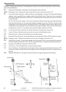
Leg - The straight segments of a route between
waypoints. A route with four waypoints has
three legs.
MOB - Man overboard.
MOB function - Starts navigating back to the
place where someone fell overboard
(see section 2-5).
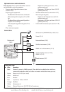
NavBus - A way of connecting NAVMAN
instruments together to share data
(see section 15-9).
NMEA - National Marine Electronics
Association.
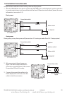
NMEA 0183 - A standard for interfacing marine
electronic devices (see section 15-10).
Route: Two or more waypoints linked in
sequence to form a course for the boat (see
section 6).
User card - A plug-in card that stores
waypoints, routes and tracks (see section 12).
UTC - Universal Time Coordinated or
Coordinated Universal Time, which is
a standard world time, formerly called
Greenwich Mean Time (GMT).
Waypoint - A position that you can set on the
TRACKER chart, for example a fishing spot or a
point on a route (see section 5).
Glossary
Appendix C - Glossary and navigation data
www.Busse-Yachtshop.de email: info@busse-yachtshop.de