


TRACKER 5505/5505i/5605 Installation and Operation Manual
16
NAVMAN
A waypoint is a position that you can set on the
TRACKER chart, for example a fishing spot or a
point on a route (see section 5).
Going to a waypoint from the chart display
1 Go to the chart display.
2 Move the cursor to the waypoint: either use
the cursor keys or use Find (see section 3-2-5).
3 Press and select Goto.
3-1-2 Going to a waypoint or to a point on the chart
Going to a waypoint from the waypoints
display
1 Go to the waypoints display.
2 Press or to highlight the waypoint to
go to.
3 Press and select Goto.
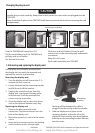
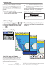
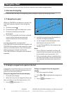
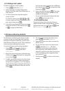
3-1-1 Navigating to a point
When the TRACKER is navigating to a point, the
chart and highway displays show navigation
data:
A The boat position .
B The destination point marked with a circle.
C The boat’s plotted course to the
destination.
D Two CDI lines, parallel to the boat’s plotted
course, which indicate the maximum
expected deviation from the plotted
course.
For more information, see appendix C.
If the TRACKER is connected to an autopilot, the
TRACKER will send data to the autopilot to steer
the boat to the destination. Start the autopilot
before starting to navigate to the point.
If the TRACKER has no autopilot, steer the boat
manually:
a use the boat position and destination on
the chart or highway displays
b or use navigation data displayed on the
data header (see section 2-8-2)
c or use COG and BRG on the compass (see
section 2-8-3).
Note:
1 If the XTE alarm is enabled, an alarm will
sound if the boat deviates too much from
its intended course (see section 14-7).
2 If the arrival radius alarm is enabled, then
an alarm will sound to show that the boat
has reached the destination (see section
14-7).
A
C
D
D
B
3 Navigation: Chart
3-1 Overview of navigating
The chart display shows the chart, the boat’s position course and navigation data.
The TRACKER has two ways of navigating, going straight to a point or following a route.
www.Busse-Yachtshop.de email: info@busse-yachtshop.de