


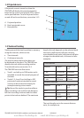


TRACKER 5505/5505i/5605 Installation and Operation Manual
29
NAVMAN
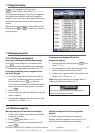
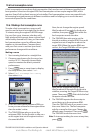
8 Gauges display
The Gauges display shows boat data, such as
water speed, as analog or digital gauges.
To go to the Gauge display, press and
select Chart, then select Chart+Gauges.
If necessary, press twice to switch to the
Gauges display (see section 2-8-1).
Before using the Gauge display, set Speed
range, Max RPM and Max fuel flow
(see sections 14-3 and 14-4).
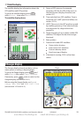
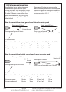
Chart
Gauges
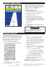
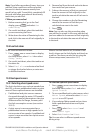
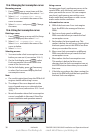
The satellite display has information about the
GPS satellites and GPS position.
To go to the satellite display, press ,
select Other, then select Satellite.
The satellite display shows:
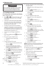
7-1 Satellite display
A
C
D
B
E
G
F
A Status of GPS antenna, for example
Acquiring, GPS fix, No GPS. If the unit is in
Simulate mode it displays Simulate (see
section 2-7)
B Time and date from GPS satellites. Time is
local time (UTC [GMT] plus local offset, see
section 14-10)
C HDOP: The error in the GPS position caused
by satellite geometry. A low value indicates
a more precise fix, a high value a less
precise fix
D Signal strengths of up to twelve visible GPS
satellites. The higher the bar the stronger
the signal
E Boat position
F Positions of visible GPS satellites:
Outer circle is horizon
Inner circle is 45° elevation
Centre is directly above
North is at top of display
G If the boat is moving, COG is a line from
centre
www.Busse-Yachtshop.de email: info@busse-yachtshop.de