


User’s Manual NAVIGON 21xx max
- 14 - Switching on the NAVIGON 21xx max
Note: The navigation application works only when the memory card
contains the navigation software and card data. You can still view
pictures when a different memory card is inserted.
2.5 Navigating with GPS
GPS is based on a total of at least 24 satellites orbiting the Earth and
continuously transmitting signals of their position and time. The GPS
receiver tracks this data and calculates its own geographical position
based on the different position and time data transmitted by the various
satellites.
Data from at least three satellites is required for positioning with an
acceptable degree of accuracy. With data from four or more satellites it
is possible in addition to determine the position's altitude above sea
level. Positioning is accurate to within three metres.
Once the navigation device has determined your position, this position
can be used as a starting point for calculating a route.
The map data on your navigation device includes the geographical
coordinates of all digitally recorded points of interest, streets and
places. This enables the device to calculate a route between a starting
point and a destination.
Calculation of the current position and its representation on the map
takes place once every second. In other words, your current position is
always shown on the map.
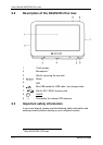
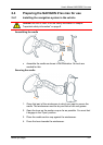
3 Switching on the NAVIGON 21xx max
1. Press the (On/Off) key.
If password protection has been activated, the E
NTER PASSWORD
window opens.
2. Enter the password.
3. Tap on OK
.
The S
TART window opens.
Note: When you switch on the NAVIGON 21xx max for the first time,
you will be asked to make the following settings:
► your preferred language for using for the software
► the unit of length for distances
► the time format
From the START window you can access all applications of the
NAVIGON 21xx max: