


151
Control systems
COMAND navigation (introduction)
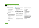
̈ Setting map orientation:
Select “Navi” Ǟ “Navi” Ǟ “Map Dis-
play”.
The map display list appears. A dot R
indicates the current setting.
̈ Select “North Up” or “Heading Up”.
̈ Exiting menu: Slide omp.
The map orientation changes accord-
ingly.
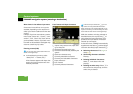
Setting POI symbols
You can set which points of interest (POIs)
should be displayed as symbols in the
map. POIs are garages, hotels, movie the-
aters or restaurants, for example.
The following settings are possible:
ț “Standard symbols” (symbol deter-
mined by the factory settings)
ț “Personal symbols” (you can determine
the symbols yourself)
ț “No symbols”
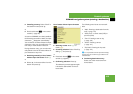
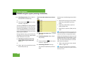
̈ Adjusting: Select “Navi” Ǟ “Navi” Ǟ
“Map Display”.
The map display list appears. A dot R
indicates the current setting.
̈ Select “Standard symbols”, “Personal
symbols” or “No symbols”.
If you select “Personal symbols”, the
list of POIs appears.
̈ Switching POI symbol display on
or off: Select the desired POI.
The corresponding symbol displays
are switched on or off, depending
on the previous status. A check-
mark indicates which status is ac-
tive. You can switch on the symbol
displays for more than one POI.
̈ Exiting menu: Slide omp or press
back button L in the center console
(
୴ page 80).
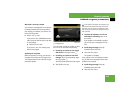
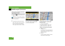
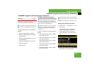
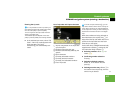
Geo-coordinate display
Illustration: map with geo-coordinate dis-
play switched on
1 Current height above sea level
2 Number of GPS satellites from which
signals for positioning can be received
3 Coordinate display
i
Depending on the map scale on the map,
POI symbols may not be visible on the map al-
though their display is activated. In addition, POI
symbols may be covered by the map’s labels.
i
The list shows all symbols that are contained
in the digital map across all states (USA) and/or
provinces (CDN). Not all POIs in all states (USA)
or in all provinces (CDN) are available, however.
Certain POI symbols may not be displayed on the
map, even if the symbol display is switched on.