


Outdoor Navigation 35
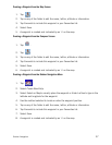
Changing Regions
1. Accesses the Outdoor Navigation application. (From the Map screen, tap the
MENU button.) NOTE: If you have an active trip you will need to cancel it before
being able to select a region from the SD card.
2. Tap the Right Arrow in the bottom right-hand corner to access page 2 of the menu.
3. Select Select Region.
4. Tap Yes.
5. Select the map you want to load.
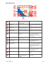
Special Terminology
Waypoints
A waypoint is similar to an address. An address uses the street name and number, the
city, and the state to define its location, whereas a waypoint uses imaginary lines drawn
on the globe (latitude and longitude) to pinpoint its location. They function in the same
way, but are defined differently.
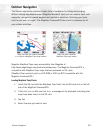
Track
Track is a record of your travels. As you move across the land the Magellan CrossoverGPS
drops and records electronic breadcrumbs that represent your movement. When you look
at the map screen you will notice a dotted line showing you a history of how you travelled.
This dotted line is your track. Track is primarily used to create a backtrack trip that
returns you to your starting point.
Backtrack
As explained above, the Magellan CrossoverGPS records your track while you are moving.
You can then create a trip (called backtrack) that follows this track back to where you
started.
Goto
A goto is a trip that tries to go in a straight line from your present position to a waypoint or
a point you have selected on the map.
Trip
A trip is a route with a single destination or with multiple legs and destinations. Suppose you
want to leave your basecamp and go to the bridge. From the bridge, you want to hike to a
scenic spot you found during your last hike. This would be a trip with two destinations (or
two legs). You would use the Magellan CrossoverGPS to create a trip that goes from your
basecamp waypoint, to the bridge waypoint, and finally to the scenic waypoint.