


Marine Navigation 33
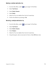
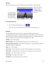
Bow View
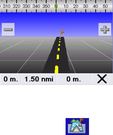
With an active trip you can use the Bow View to help navigate to your destination.
Accessing the Bow View
1. From the Marine Navigation menu, tap .
Select "X" in the bottom right-hand corner to return to the Map screen.
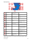
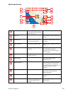
Data fields
The data fields at the bottom of the map, compass and Bow View screens are
customisable allowing you to display the data that is most relevant for you. Tap and hold
down the field for 3 seconds to display a popup menu with a list of available data. Tap
any type of data from the list and it will be displayed in the field.
Heading - your current heading.
Maximum Speed - the maximum speed recorded since you started your trip.
Off course (Cross Track Error) - the difference between your current heading and what it
should be to reach your destination.
Speed - your current speed.
Time to Last - the estimated time of arrival to the last waypoint in your active trip.
Time to Next - the estimated time of arrival to the next waypoint in your active trip.
Track Legs - the number of legs on your track.
Track Length - the length of your track.
Trip Distance - the total distance of your active trip.
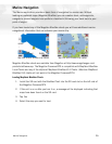
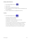
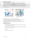
The three data fields at
the bottom of the display
are customisable. Tap and
hold down the data field
for 3 seconds. A popup
menu will appear with a
list of available data types.
When your destination is
behind you or to your left
or right, a red arrow
indicates the correct
direction you need to head
in, in order to reach your
destination.