


Marine Navigation 26
Marine Navigation
The Marine application provides a basic form of navigation for marine use. Without
loading any external maps (Magellan BlueNav) you can create a track, add waypoints,
navigate to a saved waypoint and perform a backtrack (following your track back to your
point of origin).
If you have loaded any of the Magellan BlueNav charts you will have additional marine
navigational information that can enhance your marine trip.
Magellan BlueNav charts are available from Magellan at http://www.magellangps.com/
products/software.asp. The Magellan CrossoverGPS is compatible with MapSend BlueNav
Local Charts and any of the eXplorist MapSend BlueNav XL3 Charts. (Meridian MapSend
BlueNav XL3 charts will not work in the Magellan CrossoverGPS.)
Loading MapSend BlueNav Charts
1. Install the SD card with the BlueNav Chart into the SD card slot on the left side of
the Magellan CrossoverGPS.
2. If the unit is on or after you turn it on, a message will be displayed indicating that
maps have been found on the SD card.
3. Tap Yes.
4. Select the map you want to load.
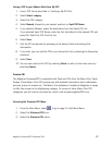
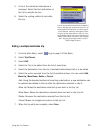
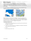
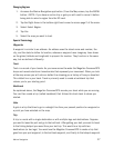
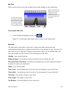
Map view without BlueNav map loaded Map view with BlueNav map loaded