


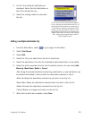

Marine Navigation 28
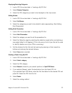
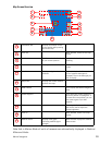
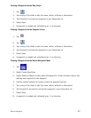
Map Screen Overview
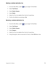
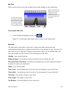
Note that in Marine Mode all units of measure are automatically displayed in Nautical
Miles and Knots.
Information Bar Displays information for the
cursor position while panning
around the map.
Zoom out When selected, zooms out the map
display.
Position Icon Provides a visual indication
of your current position.
Icon points in the direction you are
travelling
North indicator Arrow points towards North. When selected, displays the Locate
screen.
Data field Displays navigation data
selected.
Tap and hold down for 3 seconds.
A list of possible data types is
displayed. Tap on the data type you
wish to display.
Map Scale Displays the current distance
scale for the map.
MENU Button Tap to display the Marine Navigation
menu.
Create Waypoint Tap to save your current position or
the cursor position as a waypoint. If
you save the cursor position, you can
also create a goto trip to that
waypoint.
Brightness When tapped displays a slider bar
that can be used to adjust the
display brightness.
Zoom In When selected, zooms in the map
display.
Satellite Status Displays a bar graph
indicating satellite signal
strength.
When selected displays the Satellite
Status screen.
1
2
3
4
5
6
7
8
9
10
11
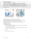
1
2
3
4
5
6
7
8
9
10
11