


55
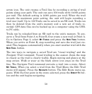
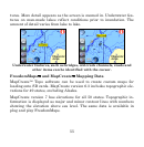
tures. More detail appears as the screen is zoomed in. Underwater fea-
tures on man-made lakes reflect conditions prior to inundation. The
amount of detail varies from lake to lake.
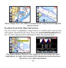
Underwater features, such as bridges, old creek channels, roads and
other items can be identified with the cursor.
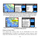
FreedomMaps™ and MapCreate™ Mapping Data
MapCreate™ Topo software can be used to create custom maps for
loading onto SD cards. MapCreate version 6.3 includes topographic ele-
vations for 49 states, excluding Alaska.
MapCreate version 7 has elevations for all 50 states. Topographic in-
formation is displayed as major and minor contour lines with numbers
showing the elevation above sea level. The same data is available in
plug and play FreedomMaps.