


44
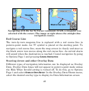
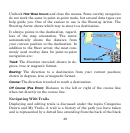
Point-to-Point Navigation
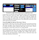
The unit can use optional "plug and play" map cards available through
LEI, the source for Lowrance accessories. Optional maps include: Nau-
ticPath™ USA marine charts, Fishing Hot Spots
®
Elite lake maps,
Navionics
®
marine charts, FreedomMaps™ for North America and
Europe, and LakeMaster
®
ProMaps.
Caution:
The unit is designed to be used inside an automobile. The mounting
bracket included with the XOG package is not designed for boats, mo-
torcycles or off-road vehicles. These installation types require an op-
tional bracket and cradle designed for rugged outdoor use. The unit's
case is not waterproof. If used in wet conditions the unit must be pro-
tected from moisture.
The unit also can display custom maps prepared by LEI's MapCreate™
topographical mapping software and Lowrance Enhanced Lake Maps
that can be downloaded free from the Lowrance web site,
www.lowrance.com. Turn-by-turn navigation does not work with any of
these optional maps.
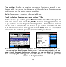
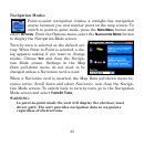
When using optional maps, you must search for POIs using the
SEARCH
ALL POIS BY NAME button in the Find 2 menu. Other search categories
will not work. If a POI symbol is selected on the map screen with the
cursor, pressing the Location-POI Information button displays a POI
information screen for that item.