


50
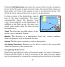
arrow icon. The unit creates a Trail line by recording a string of trail
points along your path. The unit can save 100 trails with 10,000 points
per trail. The default setting is 2,000 points per trail. When the trail
exceeds the maximum point setting, the unit will begin recording a
trail over itself. Up to 100 Trails can be saved to an SD card. Trails can
then be deleted from the unit's memory and a new set of trails re-
corded. GPS data files can be backed up on a computer using the USB-
to-PC cable.
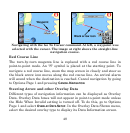
Trails can be reloaded from an SD card to the unit's memory. To pre-
serve a Trail from Point A to Point B, first create a new trail at Point A.
Go to Options Page 2, select
MY TRAILS and press the NEW TRAIL button.
When you arrive at Point B, stop recording and save the trail just cre-
ated. This happens automatically when you start another trail with the
NEW TRAIL button.
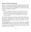
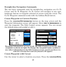
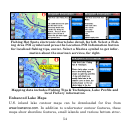
The two ways to navigate a saved Trail are "visual trailing" and the
Navigate Trail command. Visual trailing is the easiest. Zoom the map
in closely so the trail is clearly visible. Begin moving and glance at the
map screen. Walk or steer so the black arrow icon stays on the Trail
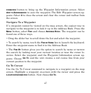
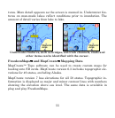
line. The Navigate Trail command converts a trail into a route. Select
MY TRAILS. When you select a trail from the Trail Menu the Edit Trail
menu will appear. Press the
NAVIGATE button. The Edit Route menu ap-
pears. With the first point in the route selected, press the
DIRECT TO but-
ton and the unit begins navigating.