


80
3. All the menus are cleared and the unit reverts to the Map Page at
the 4000 mile zoom range, just as if you had turned it on for the first
time. All options have been returned to the factory settings.
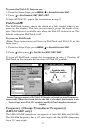
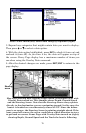
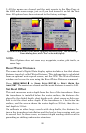
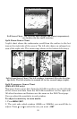
System Setup menu with Reset Options selected (left). The Reset Op-
tions dialog box, with "Yes" selected (right).
NOTE:
Reset Options does not erase any waypoints, routes, plot trails, or
sonar logs.
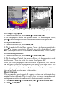
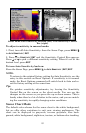
Reset Water Distance
The sonar chart's Digital Data display option includes a box that shows
distance traveled, called Water Distance. This information is calculated
from an optional water speed sensor, not the GPS. The Water Distance
window can be reset to zero using the Reset Water Distance command.
Press
MENU|MENU|↓ to SONAR SETUP|ENT|↓ to RESET WATER DIS-
TANCE
|ENT. The menus are cleared and the water distance is reset to 0.00.
Set Keel Offset
This unit measures water depth from the face of the transducer. Since
the transducer is installed below the water surface, the distance dis-
played by the digital depth, chart depth scale, chart cursor or fish sym-
bols is not the exact water depth. If the transducer is 1 foot below the
surface, and the screen shows the water depth as 30 feet, then the ac-
tual depth is 31 feet.
On sailboats or other large vessels with deep drafts, the distance be-
tween the transducer installation and the keel or lower engine unit can
be several feet. In those cases, an inexact depth reading could result in
grounding or striking underwater structure.