


126
To stop navigating to the cursor, use the Cancel Navigation command:
press
MENU|MENU|↓ to CANCEL NAVIGATION|ENT|← to YES|ENT. The unit
stops showing navigation information.
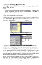
Navigate to a Point of Interest
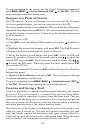
For POIs that are in view on the map, you can easily use the Navigate
to Cursor command above; just use the cursor to select the POI.
The other method involves searching for POIs with the Find Waypoint
command, launched with the
WPT key. (See the searching example ear-
lier in this section, or turn to Sec. 9, Searching, for detailed instructions
on POI searches.)
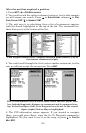
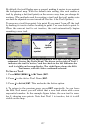
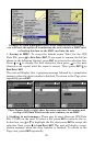
To Navigate to a POI:
1. Press
WPT, select the desired POI category, then press → to Subcate-
gory.
2. Highlight the desired subcategory and press
ENT. The Find By menu
will appear with two search options: Name of Nearest.
3. Select the desired search option and press
ENT. A list of POIs will
appear. If you chose Nearest as the search option, use ↑ ↓ to select the
desired POI and press
ENT. If you chose to search by Name, use ↑ ↓, ←
→ to input the POI name. When the name has been entered press
ENT
to access the POI list.
4. Select the desired POI and press
ENT, which will open the Waypoint
Information menu.
5. Highlight
GO TO WAYPOINT and press ENT. The unit begins showing
navigation information to the item.
To cancel navigation, press
MENU|MENU|↓ to CANCEL NAVIGATION|ENT|←
to
YES|ENT. The unit stops showing navigation information.
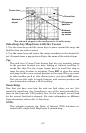
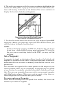
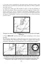
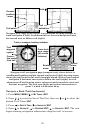
Creating and Saving a Trail
A trail, or plot trail, is a string of position points plotted by the unit as
you travel. It's a travel history, a record of the path you have taken.
Trails are useful for repeating a journey along the same track. They are
particularly handy when you are trying to retrace your trip and go back
the way you came. On the screen, trails are represented by a solid line
extending from the back of the current position arrow.
The unit is set at the factory to automatically create and record a trail
while the unit is turned on. The unit will continue recording the trail
until the length reaches the maximum trail point setting (default is
2,000, but the unit can record trails 9,999 points long). When the point
limit is reached, the unit begins recording the trail over itself.