


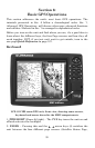
103
Background map vs. MapCreate map content
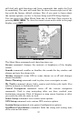
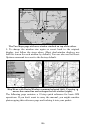
The background map includes: low-detail maps of the whole world,
containing cities, major lakes, major rivers, political boundaries, and
medium-detail maps of the United States.
The medium-detail U.S. maps contain: all incorporated cities, shaded
metropolitan areas, county boundaries, shaded public lands (such as
national forests and parks) and some major city streets. Also included
are Interstate, U.S. and state highways, highway exits and exit services
information, large and medium-sized lakes and streams and more than
60,000 navigation aids with 10,000 wrecks and obstructions in U.S.
coastal and Great Lakes waters.
NOTE
The LCX-26CHD and LCX-111CHD have Nautic Path charts,
HotSpots Elite charts and all high detail custom maps preloaded on
a 20 Gigabyte hard drive. Therefore, if you own either the LCX-
26CHD or LCX-111CHD, you do not need to load any of those
charts/maps into the unit. The unit can also use Navionics charts,
but they must be loaded via a Navionics card. MMC and SD cards
still will be necessary to log sonar chart data and to store GPS data
files.
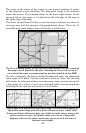
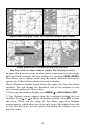
MapCreate custom maps include massive amounts of information not
found in the background map. MapCreate contains: Points of Interest
database, all the minor roads and streets, all the landmark features
(such as summits, schools, radio towers, etc.); more rivers, streams,
smaller lakes and ponds and their names.
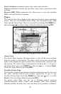
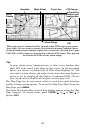
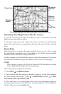
What's more important is the large-scale map detail that allows your
GPS unit to show a higher level of position accuracy. For example, the
background map would show you the general outline and approximate
shape of a coastline or water body, but the higher detail in MapCreate
shows the shoreline completely and accurately. Many smaller islands
would not be included in the background map, but are in MapCreate.