


66
Navionics
Charts
Your unit can display Navionics
electronic charts on MMCs. Both the
GOLD and CLASSIC format charts are accepted. They work just
like a MapCreate custom map on an MMC.
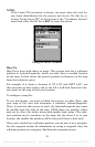
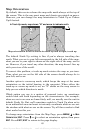
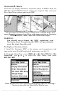
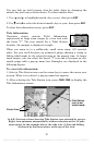
Left, entrance to Aransas Pass in a MapCreate 6 custom map, 4 mile
zoom. Remaining images, from left to right: same position on Navionics
GOLD chart at 8 mile, 4 mile and 1 mile zoom ranges.
WARNING:
You should never format the MMC containing your
Navionics chart. Formatting the MMC will permanently
erase the chart from the card.
To display a Navionics chart:
1. Install the Navionics MMC in the memory card compartment and
turn on the unit. (For full card install instructions, see Sec. 2.)
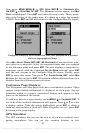
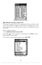
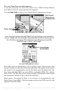
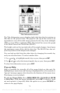
2. From the Map Page, press
MENU|↓ to MAP DATA|ENT|↓ to MAP
CHOICE|ENT. Use ↑ or ↓ to select the Map Name, then press
ENT|EXIT|EXIT.
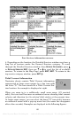
These figures show menu sequence (from left to right) for selecting a
Navionics chart for the West Gulf of Mexico area.
offered by www.Busse-Yachtshop.de email: info@busse-yachtshop.de Tel: +49 (0)4347 908234