


59
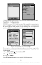
Now press
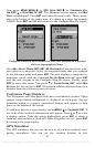
MENU|MENU|↓ to GPS SETUP|ENT|↓ to COORDINATE SYS-
TEM
|ENT|↓ to SETUP MAP FIX|ENT. The following screens appear, and MAP
SCALE is highlighted. Press ENT and enter the map's scale. This is gener-
ally at the bottom of the paper map. It's shown as a ratio, for example
1:24000. Press
EXIT and the unit returns to the Configure Map Fix screen.
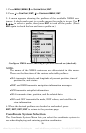
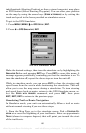
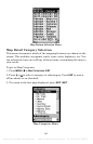
Configure a map fix so iFINDER can find your position on a printed
chart or topographical map.
Press ↓ to SELECT ORIGIN|ENT|ENT (MY WAYPOINTS) if you saved the refer-
ence point as a waypoint. Select the waypoint name that you assigned
to the reference point and press
ENT. The unit displays a waypoint in-
formation screen with the command
SET AS ORIGIN selected; press ENT
and the unit returns to the Configure Map Fix menu. Finally, press
EXIT to erase this menu. Now press ↑ to COORD SYSTEM|ENT, select MAP
FIX from the list and press ENT. All position information now shows as a
distance from the reference point you chose.
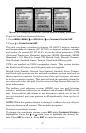
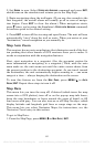
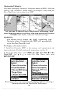
Customize Page Displays
The Navigation and Map pages both have customizable options. These
options control which information is displayed on each page. Any in-
formation added to a page's customized display will appear in data
boxes at the bottom of the screen.
To add new data to a page display, press
MENU|↓ to CUSTOMIZE|ENT. A
list of all of the available information will appear. Press ↓ or ↑ to select
a display option. With the option highlighted, press
ENT to check it
(turn on) and uncheck it (turn off.) After all options are set, press
EXIT
to return to the page display.
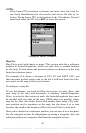
GPS Simulator
The GPS simulator lets you use the unit as if you were outdoors navi-
gating somewhere. You can set the starting location in lati-
offered by www.Busse-Yachtshop.de email: info@busse-yachtshop.de Tel: +49 (0)4347 908234