


47
NOTE:
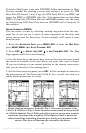
Search works from mapping and POI data loaded in iFINDER. If
you do not have a high-detailed custom map (containing POI data)
for the area you are searching loaded on the MMC, you may not
find anything.
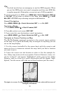
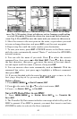
Trails
A trail, or plot trail, is a string of position points plotted by iFINDER as
you travel. It's a travel history, a record of the path you have taken.
Trails are useful for repeating a journey along the same track. They are
particularly handy when you are trying to retrace your trip and go back
the way you came.
The iFINDER lets you save up to 10 trails in its memory. Since you can
copy these trails to MMCs in the form of GPS Data Files (*.usr format),
the only true limit on the number of trails you can record is the number
of MMCs you can carry in your pockets.
(For various trail options, see the Trail Options entry in Sec. 5.)
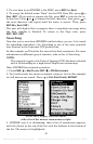
Create and Save a Trail
iFINDER is set at the factory to automatically create and record a trail
while the unit is turned on. It will continue recording the trail until the
length reaches the maximum trail point setting (default is 2,000, but
the unit can record trails 9,999 points long). When the point limit is
reached, iFINDER begins recording the trail over itself.
To preserve a trail from point A to point B, you must :"turn off" the trail
by making it inactive before heading to point C or even back to point A.
When a trail is set inactive, iFINDER automatically creates and begins
recording a new trail.
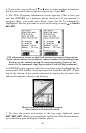
Delete a Trail
To erase or delete a trail, press
MENU|MENU|↓ to MY TRAILS|ENT|↓ to
trail name|
ENT|↓ to DELETE TRAIL|ENT|← to YES|ENT.
Edit a Trail Name
To edit a trail name: press
MENU|MENU|↓ to MY TRAILS|ENT|↓ to trail
name|
ENT|ENT. Press ↑ or↓ to change the first character, then press →
to the next character and repeat until the name is correct. Press
EXIT|EXIT|EXIT|EXIT to return to the previous page display.
offered by www.Busse-Yachtshop.de email: info@busse-yachtshop.de Tel: +49 (0)4347 908234