


43
Navigating to a Cursor Position
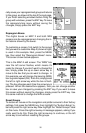
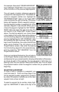
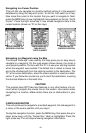
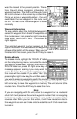
This unit lets you navigate to a location without storing it in the waypoint
database by using the map and cursor. To do this, first switch to a map.
Now move the cursor to the location that you want to navigate to. Next,
press the MENU key. A new, highlighted menu appears on the list: “Go To
Cursor”. Press the right arrow key. It now shows navigation data to the
cursor location (shown as “D” on the map).
MOVE CURSOR TO
DESIRED LOCATION
PRESS MENU KEY,
THEN SELECT
"GOTO CURSOR"
NAVIGATING TO
CURSOR POSITION
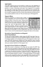
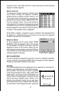
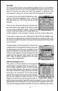
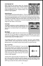
Navigating to a Waypoint using the Map
The unique “birds-eye” view used by the map gives you an easy way to
navigate to a waypoint. On the map screen shown above, the arrow is
your present position. The box with the “S” in it was your starting location
when the waypoint was recalled. The dotted line is called a course line
and is the shortest path from the starting location to the destination. The
“D” is the cursor destination, when the cursor position is used as a desti-
nation. If you follow the course line, you’ll reach the destination, covering
the shortest distance in the least time.
CAUTION!
This product does NOT take land features or any other feature into ac-
count when it projects the course line on the screen. Use caution when
navigating to a location. Make certain there are no obstructions in your
path.
CANCEL NAVIGATION
This unit continues to navigate to a recalled waypoint, the last waypoint in
a route, or the cursor position until you stop it.
To stop the navigation function, press the MENU key, then press the up or
down arrow keys until the “Cancel Nav” label is highlighted. Press the
right arrow key. The unit stops showing navigation information.