


24
Gray Fill
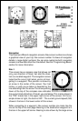
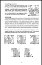
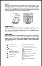
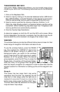
When this unit is first turned on, all water (lakes, oceans, rivers) is filled
with gray to distinguish it from land, which is clear. (See below) To make
the land fill with gray and water remain clear, select the “Fill with Gray”
label from the Map Detail menu, then press the left arrow key. Press the
EXIT key repeatedly to return to the mapping screen.
WATER FILLED
WITH GRAY
LAND FILLED
WITH GRAY
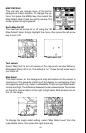
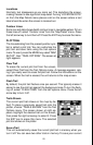
Map Boundaries
By default, this unit draws a line around areas of the map that have more
detail than the background map. This line depicts the detailled map bound-
aries. To turn this off, select “Map Bounds” from the map details menu,
then press the left arrow key.
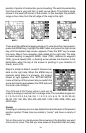
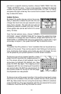
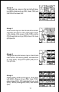
Map Symbols
When the nav aid data is downloaded to this unit, buoys and other naviga-
tional aids can be turned off or on by using “Map Symbols” on the “Map
Details” menu. To find this menu, press the down arrow key while on the
“Map Details” menu until “Map Symbols” appears. Press the left arrow key
to turn them off.
LIGHTED BUOY
UNLIGHTED BUOY
LIGHT
SQUARE DAYBEACON
TRIANGLE DAYBEACON
RADIO BEACON
PLATFORM
INTERSTATE HIGHWAY
U.S. ROUTE HIGHWAY
U.S. ALTERNATE ROUTE HWY.
STATE HIGHWAY
COUNTY ROUTE
TRANS-CANADA HIGHWAY
CANADIAN (QUEBEC)
AUTOROUTE
MEXICAN FEDERAL HWY.