


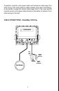
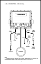

11
to calculate a position. Speed, direction of travel, and distance are all
calculated from position information. Therefore, in order for it to determine
direction of travel, you must be moving and the faster, the better. This is
not to say that it won’t work at trolling speeds - it will. There will simply be
more “wandering” of the data shown on the display.
Another factor that greatly influences the receiver’s ability to determine
position is SA. The United States government intentionally degrades the
satellite’s signal for civilian users. They introduce small errors into the
signals that makes the GPS receiver less accurate. These errors are called
selective availability, or SA. How bad is it? They guarantee that the posi-
tion reported by a GPS receiver that meets their specifications is within
100 meters horizontally and 150 meters vertically 95% of the time. (The
position can be worse than that the other 5% of the time.) In other words,
the position shown on your receiver is within 100 meters of your actual
position, 95% of the time. That’s over 300 feet! Not exactly pinpoint accu-
racy, but then few people need positioning accuracy greater than this.
However, if you do want better performance, (and who doesn’t?) many
manufacturers (including Lowrance) sell a DGPS receiver that attaches
to your GPS receiver. The DGPS system transmits correction signals that
nullify the effects of SA. The DGPS receiver takes signals from these
land-based transmitters and gives them to the GPS receiver which then
uses them to show a more accurate position. The ironic part is the federal
government implemented SA and is also operating many DGPS transmit-
ters. (You can use the signals from all of the Coast Guard DGPS stations
for free, by the way.) The downside to this is it requires another piece of
electronic gear (the DGPS receiver). And you have to be close enough to
a station to receive the DGPS signals.
Generally, you find that using your GPS receiver without DGPS is both
easy and amazingly accurate. It’s easily the most accurate method of
electronic navigation available to the general public today. Remember,
however, that this receiver is only a tool. Always have another method of
navigation available, such as a chart or map and a compass.
Also remember that this unit will always show navigation information in
the shortest line from your present position to a waypoint, regardless of
terrain! It only calculates position, it can’t know what’s between you and
your camp, for example. It’s up to you to safely navigate around obstacles,
no matter how you’re using this product.