


24 CONTENTS TH-D72A/E
4 GPS
GPS, standing for Global Positioning System, is becoming common nowadays and following is a brief
introduction.
The American Defense Department developed GPS originally for military operations. The system is
available for use by the general public. For example, anybody can use GPS in association with
modern vehicle navigation systems. Position precision for public use is 15 m or 50 feet. Moreover,
precision can be improved when used for vehicle navigation and aboard ships through use of map
matching technology and differential GPS techniques.
A total of 24 or more GPS satellites are at a high-level altitude of approximately 20,000 km or 12,500
miles on six circular tracks with orbital radii of approximately 26,000 km or 16,200 miles. Therefore,
there are four or more satellites located in each orbital track. GPS typically operates at the frequency
of 1575.42 MHz with the bandwidth of 2.046 MHz. Because multiple GPS satellites transmit signals
at the same frequency, spread-spectrum (SS) modulation is used. Due care must be taken when
installing amateur radio equipment and antennas for use on the 430 MHz or 1200 MHz bands to
prevent from interfering with GPS signals.
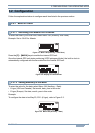
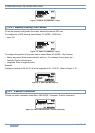
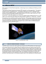
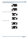
Figure 4-1 GPS IIR Satellite in Orbit
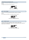
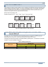
The GPS receiver receives the radio signals transmitted from the GPS satellites and measures the
time duration between when the signal leaves the satellite and when the signal arrives at the GPS
receiver. The receiver measures the time duration between when the signal leaves the satellite and
when the signal arrives at the GPS receiver. Knowing this time allows calculation of the distance that
the signal traveled from that particular satellite. By receiving multiple signals from different satellites
and doing this distance calculation multiple times, the intersection of the spherical surfaces that
represent the respective radius distances to the various satellites will determine a single point. The
precision of the determination of the intersecting point relies on the satellites and the data collected.
4.1 What is GPS?
4.1.1 Position Determination Principle