


2 HOW YOU ENJOY APRS WITH TH-D72A/E (WRITTEN BY BOB BRUNINGA, WB4APR)
12 CONTENTS TH-D72A/E
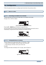
Digipeater Path Information
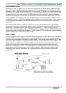
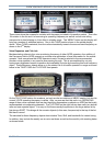
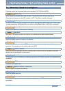
Another new information feature of TH-D72A/E is
the digipeater path display shown here. This display
shows the First and Last digipeaters used. Most
APRS areas encourage the use of only 2 hops or
less. This means, in most cases, the full path is
visible. In this image the WB3V-6 packet was First
heard by the N3KTX-1 digipeater and then it was
delivered to my radio by the Last hop on the KV3B-2
digipeater. This path knowledge is very valuable to
the operator in understanding his local area
network. This display is just one of the 9 pages of
additional information available on each station
heard by TH-D72A/E and captured in the station list.
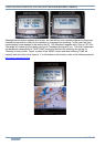
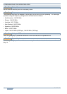
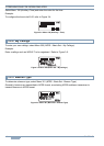
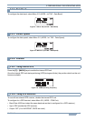
APRS Radio Map Capabilities
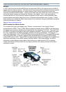
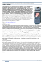
All of the Kenwood APRS radios can display all stations in the Station list on any attached GPS map
display if the GPS supports standard NMEA waypoints. These stations are shown with the GPS's
native generic waypoint symbol except for those that are compatible with the special Kenwood
interface such as the AvMap G5/G6 which has the full APRS symbol set (shown below) and the
Garmin nuvi 350 which requires the corresponding conversion cable supplied by Argent Data System
and has about 50 different symbols. The nuvi 350 needs a GTRANS Kenwood to Garmin translator
cable available from http://argentdata.com. The AvMap is designed for 100% compatibility with the
nearly 200 APRS symbols. The data cable manufactured by Argent translates the special Kenwood
data format into the 50 or so Garmin symbol set where possible.
(Image of AvMap by Don Arnold, W6GPS and nuvi 350 by Mike Wren, N2QDK)
Other APRS Information Resources
The information available to the mobile operator is unlimited. APRS is not an end in itself, but the
information is not available if no one is transmitting it. The potential is still wide open for additional
content. This is not spam, but real immediate information of value to the mobile or traveler. There
are many examples of data sources that have been implemented in some local areas.
Traffic speeds at select choke points: refer to: http://aprs.org/traffic.html
MF Mobile Satellites in view: refer to: http://aprs.org/satinfo.html
UI-InfoKiosk local info database: refer to http://www.apritch.myby.co.uk/infokiosk.htm.