


Cirrus Perspective
®
by Garmin – Cockpit Reference Guide for the SR20/SR22
190-00821-03 Rev. A
50
Hazard Avoidance
Flight
InstrumentsEIS
Nav/Com/
XPDR/AudioAFCSGPS Nav
Flight
PlanningProcedures
Hazard
Avoidance
Additional
Features
Abnormal
Operation
Annun/
AlertsAppendixIndex
Displaying Traffic on the Navigation Map
1)
Ensure TAS is operating.
2)
With the Navigation Map displayed, press the MAP Softkey.
3)
Press the TRAFFIC Softkey. Traffic is now displayed on the map.
TERRAIN AND OBSTACLE PROXIMITY
NOTE: Terrain data is not displayed when the aircraft latitude is greater than
75 degrees north or 60 degrees south.
Displaying Terrain and Obstacles on the Terrain Proximity Page
1)
Turn the large
FMS
Knob to select the Map Page Group.
2)
Turn the small
FMS
Knob to select the Terrain Proximity Page.
3)
If desired, press the
VIEW
Softkey to access the
ARC
and
360
Softkeys.
When the
ARC
Softkey is pressed, a radar-like 120° view is displayed. Press
the
360
Softkey to return to the 360° default display.
4)
Rotate the
Joystick
clockwise to display a larger area or rotate counter-
clockwise to display a smaller area.
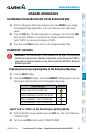
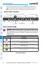
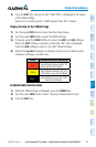
Color Terrain/Obstacle Location
Red
Terrain/Obstacle above or within 100’
below current aircraft altitude.
Yellow
Terrain/Obstacle between 100’ and
1000’ below current aircraft altitude.
Black
Terrain/Obstacle is more than 1000’
below aircraft altitude.
Displaying Terrain and Obstacles on the Navigation Map
1)
With the Navigation Map displayed, press the
MAP
Softkey.
2)
Press the
TERRAIN
Softkey. Terrain and obstacle proximity will now be
displayed on the map.