


Cirrus Perspective
®
by Garmin – Cockpit Reference Guide for the SR20/SR22
190-00821-03 Rev. A 25
GPS Navigation
Flight
Instruments EIS
Nav/Com/
XPDR/Audio AFCS GPS Nav
Flight
Planning Procedures
Hazard
Avoidance
Additional
Features
Abnormal
Operation
Annun/
Alerts Appendix Index
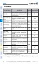
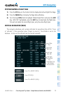
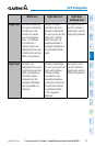
White Text Light Blue Text Light Blue
Subdued Text
Large Text
Altitude calculated by
the system estimating
the altitude of the
aircraft as it passes
over the navigation
point. This altitude
is provided as a
reference and is not
designated to be used
in determining vertical
flight path guidance.
Altitude has been
entered by the pilot.
Altitude is designated
for use in giving vertical
flight path. Altitude
does not match the
published altitude in
navigation database or
no published altitude
exists.
The system cannot
use this altitude in
determining vertical
flight path guidance.
Small Text
Altitude is not
designated to be used
in determining vertical
flight path guidance.
Altitude has been
retrieved from the
navigation database
and is provided as a
reference.
Altitude is designated
for use in giving vertical
flight path guidance.
Altitude has been
retrieved from the
navigation database
or has been entered by
the pilot and matches
a published altitude
in the navigation
database.
The system cannot
use this altitude in
determining vertical
flight path guidance.