


Cirrus Perspective
®
by Garmin – Cockpit Reference Guide for the SR20/SR22
190-00821-03 Rev. A 29
Flight Planning
Flight
Instruments EIS
Nav/Com/
XPDR/Audio AFCS GPS Nav
Flight
Planning Procedures
Hazard
Avoidance
Additional
Features
Abnormal
Operation
Annun/
Alerts Appendix Index
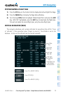
CREATE A NEW USER WAYPOINT DEFINED BY LATITUDE & LONGITUDE
1)
Turn the large FMS Knob on the Control Unit to select the ‘WPT’ page group.
2)
Turn the small FMS Knob to select the User WPT Information Page.
3)
Press the NEW Softkey. A waypoint is created at the current aircraft
position.
4)
Enter the desired waypoint name.
5)
Press the ENT Key.
6)
The cursor is now in the ‘WAYPOINT TYPE’ field. If desired, the waypoint
can be made temporary (deleted automatically when the system is turned
off). If the waypoint is to remain in the system, proceed to step 7.
a)
Turn the large FMS Knob one click to the left to highlight
‘TEMPORARY’.
b)
Press the ENT Key to place a check-mark in the box.
7)
The cursor is now in the ‘WAYPOINT TYPE’ field. Turn the small FMS Knob
to display a list of waypoint types.
8)
Turn the small FMS Knob to select LAT/LON (latitude and longitude).
9)
Press the ENT Key.
CREATE A NEW USER WAYPOINT DEFINED BY RADIALS FROM OTHER
WAYPOINTS
1)
Turn the large FMS Knob on the Control Unit to select the ‘WPT’ page group.
2)
Turn the small FMS Knob to select the User WPT Information Page.
3)
Press the NEW Softkey. A waypoint is created at the current aircraft
position.
4)
Enter the desired waypoint name.
5)
Press the ENT Key.
6)
The cursor is now in the ‘WAYPOINT TYPE’ field. If desired, the waypoint
can be made temporary (deleted automatically when the system is turned
off). If the waypoint is to remain in the system, proceed to step 7.
a)
Turn the large FMS Knob one click to the left to highlight
‘TEMPORARY’.
b)
Press the ENT Key to place a check-mark in the box.