


Cirrus Perspective
®
by Garmin – Cockpit Reference Guide for the SR20/SR22
190-00821-03 Rev. A 47
Hazard Avoidance
Flight
Instruments EIS
Nav/Com/
XPDR/Audio AFCS GPS Nav
Flight
Planning Procedures
Hazard
Avoidance
Additional
Features
Abnormal
Operation
Annun/
Alerts Appendix Index
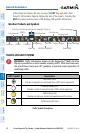
XM WEATHER (OPTIONAL)
WARNING: Use of XM weather for hazardous weather penetration is not
recommended. Weather information provided by XM Radio Service is
approved only for weather avoidance, not penetration.
Displaying XM Weather on the Navigation Map Page
1)
Press the MAP Softkey.
2)
Press the NEXRAD
and/or
XM LTNG Softkey to display the desired
weather. Press the applicable softkey again to remove weather data from
the Navigation Map Page.
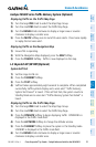
Display METAR and TAF information on the Airport Information Page
1)
Turn the large FMS Knob to select the WPT Page Group.
2)
Turn the small FMS Knob to select the Airport Information Page.
3)
Press the WX Softkey to display METAR and TAF text (METAR and TAF
information is updated every 12 minutes).
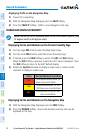
Displaying Weather on the Weather Data Link Page
1)
Turn the large FMS Knob to select the Map Page Group.
2)
Turn the small FMS Knob to select the Weather Data Link Page.
3)
Press the available softkeys to select the desired XM weather product.
4)
Press the LEGEND Softkey to view the legends for the selected products. If
necessary, turn either FMS Knob to scroll through the list. Press the small
FMS Knob or the ENT Key to return to the map.
Map Panning Information – Weather Data Link Page
1)
Push in the Joystick to display the panning arrow.
2)
Move the Joystick to place the panning arrow on AIRMETs, TFRs, METARs,
or SIGMETs.
3)
Press the ENT Key to display pertinent information for the selected product.
Note that pressing the ENT Key when panning over an AIRMET or a
SIGMET displays an information box that shows the text of the report.
Panning over an airport with METAR information does not display more