


Cirrus Perspective
®
by Garmin – Cockpit Reference Guide for the SR20/SR22
190-00821-03 Rev. A
Appendix
96
Flight
InstrumentsEIS
Nav/Com/
XPDR/AudioAFCSGPS Nav
Flight
PlanningProcedures
Hazard
Avoidance
Additional
Features
Abnormal
Operation
Annun/
AlertsAppendixIndex
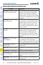
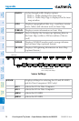
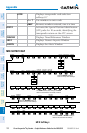
TRAFFIC
Cycles through traffic display options:
TRFC-1: Traffic displayed on inset map
TRFC-2:TrafcMapPageisdisplayedintheinset
map window
TOPO
Displays topographical data (e.g., coastlines, terrain,
rivers, lakes) and elevation scale on Inset Map
TERRAIN
Displays terrain information on Inset Map
STRMSCP
Press to display the Stormscope lightning data on
theInsetMap(withina200nmradiusoftheair-
craft)
NEXRAD
Displays NEXRAD weather and coverage informa-
tion on Inset Map (optional feature)
XM LTNG
Displays XM lightning information on Inset Map
(optional feature)
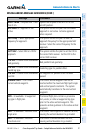
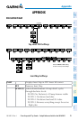
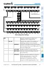
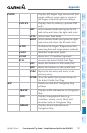
Sensor Softkeys
Press the BACK Softkey to
return to the top level softkeys.
BACK
ADC2
ADC1
AHRS1
AHRS2
ALERTS
ALERTS
(SR22 only)
SENSOR
Displayssoftkeysforselectingthe#1and#2AHRS
andAirDataComputers(SR22only)
ADC1
Selects the #1 Air Data Computer
ADC2
Selectsthe#2AirDataComputer
AHRS1
Selects the #1 AHRS
AHRS2
Selectsthe#2AHRS