


Cirrus Perspective
®
by Garmin – Cockpit Reference Guide for the SR20/SR22
190-00821-03 Rev. A
92
Annunciations & Alerts
Flight
InstrumentsEIS
Nav/Com/
XPDR/AudioAFCSGPS Nav
Flight
PlanningProcedures
Hazard
Avoidance
Additional
Features
Abnormal
Operation
Annun/
AlertsAppendixIndex
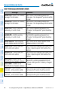
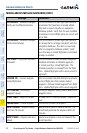
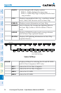
MISCELLANEOUS MESSAGE ADVISORIES (CONT.)
Message Comments
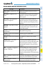
VNV
– Unavailable. Parallel course
selected.
A parallel course has been selected, causing
the vertical deviation to go invalid.
NO WGS84 WPT
– Non WGS 84
waypoint for navigation -[xxxx]
The selected waypoint [xxxx] does not use the
WGS 84 datum. Cross-check position with
alternate navigation sources.
TRAFFIC FAIL
– Traffic device has
failed.
The Perspective
®
is no longer receiving data
from the traffic system. The traffic device
should be serviced.
STRMSCP FAIL
– Stormscope has
failed.
Stormscope has failed. The Perspective
®
system
should be serviced.
FAILED PATH
– A data path has
failed.
A data path connected to the GDU or the GIA
63/W has failed.
FAILED PATH
– An autopilot servo
data path has failed.
A data path connected to an autopilot servo
has failed. Only available if GFC 700 is
installed.
MAG VAR WARN
– Large magnetic
variance. Verify all course angles.
The GDU’s internal model cannot determine
the exact magnetic variance for geographic
locations near the magnetic poles. Displayed
magnetic course angles may differ from the
actual magnetic heading by more than 2°.
SVS
– SVS DISABLED: Out of
available terrain region.
Synthetic Vision is disabled because the aircraft
is not within the boundaries of the installed
terrain database.
SVS
– SVS DISABLED: Terrain DB
resolution too low.
Synthetic Vision is disabled because a terrain
database of sufficient resolution (9 arc-second
or better) is not currently installed.
SCHEDULER [#]
– <message>. Message criteria entered by the user.
CHECK CRS
– Database course for
LOC1 / [LOC ID] is [CRS]°.
Selected course for LOC1 differs from published
localizer course by more than 10 degrees.
CHECK CRS
– Database course for
LOC2 / [LOC ID] is [CRS]°.
Selected course for LOC2 differs from published
localizer course by more than 10 degrees.