


79
GETTING START-
ED
Using the GOTO
Key
Navigation Setup
The navigation setup submenu is used to select a variety of navigation informa-
tion including: position format, units of measure, and heading references. This
submenu is also used to select map datums, set the CDI scale and adjust the built-
in velocity filter. The following options are available:
• Position Format: Lets you select the coordinate system used to display
position. The following formats are available:
• hddd.dddddº (degrees) • hdddºmm.mmm’ (degrees and minutes)
• hdddºmm’ss.s” (deg/min/sec) • British grid
• German grid • Irish grid
• Maidenhead • Swedish grid
• Swiss grid • Taiwan grid
• UTM/UPS grid • LORAN TDs
• Navigation Units: Selects the format for speed and distance measurements. You
may select from nautical, statute or metric formats. (The default setting is nautical.)
• Depth Units: Selects the format for depth contour display on G-chart offshore chart
cartridges and the sounder display. Depth contours and sounder depth units can be
displayed in feet, meters or fathoms. (The default setting is feet.)
• Temp Units: Lets you select between Celsius and Fahrenheit.
• Heading: Lets you select what reference is used in calculating heading information.
You can select to reference automatic magnetic variation, true north, grid heading
or user magnetic variation. (The default setting is automatic.)
To enter a user magnetic variation:
1. Highlight the ‘Heading’ field and press
T
. Select the ‘User Mag Var’ option and
press
T
.
2. Press
T
to access the variation field, and use the
R
keypad to enter the
desired variation. Press
T
to confirm.
SECTION
10
SETUP MENUS
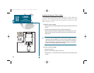
Navigation Setup
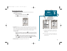
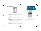
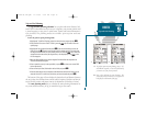
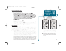
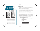
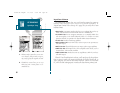
AB
A. The sounder will also display position coordinates
in eight grid formats.
B. To enter a user magnetic variation, select the
‘User Mag Var’ option and enter a direction and
value in the variation field.
19000138.10A.QXD 11/11/99 8:47 AM Page 79