


39
GETTING START-
ED
Using the GOTO
Key
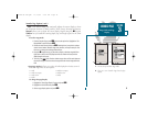
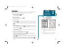
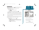
Map Page
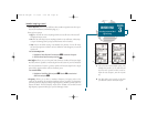
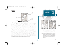
The Map Page provides a comprehensive display of electronic cartography,
plotting and navigational data. The map display shows your boat on a digital
chart, complete with geographic names, navaids, depth contours and other chart
features. It also plots your track and displays any routes and waypoints you create.
An on-screen cursor lets you pan and scroll to other map areas, determine the dis-
tance and bearing to a position, and perform various route and waypoint
functions.
The data window, located at the top of the page, provides a user-selectable dis-
play of your current course and speed over ground, along with the bearing and
distance to a destination waypoint. Whenever the cursor is active, an additional
data window will appear below to indicate the position, range and bearing to the
cursor or a selected waypoint or navaid. Each data field may be configured to dis-
play any one of thirteen data options. The data window can also be changed to
display additional data fields, a compass tape, or a CDI scale. The status bar at
the bottom of the page displays the map scale currently in use.
SECTION
4
MAP PAGE
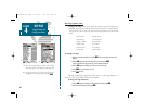
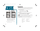
Overview
Boat
Icon
Data
Window
Map
Scale
Status
Bar
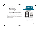
AB
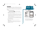
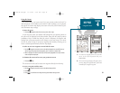
A. Use the cursor to pan ahead to other map areas.
The map display will automatically scroll for-
ward when you reach the edge of the map.
B. To select or ‘highlight’ an on-screen navaid or
waypoint, simply move the cursor over the way-
point symbol. The cursor will ‘snap’ to the way-
point, and display its name and position in the
data field.
19000138.10A.QXD 11/11/99 8:47 AM Page 39