


51
GETTING START-
ED
Using the GOTO
Key
Navigation Page Options (con’t.)
The following options are available:
• Change Data Fields?: Allows you to define the type of data that is displayed in any
of the six user-selectable data fields. Thirteen options are available:
• BRG • DIS • DPT
• SOG • COG • STW
• ETE • ETA • TMP
• XTK • VMG • TRN
• CTS
To change a data field:
1. Highlight the ‘Change Data Fields?’ option and press
T
.
2. Highlight the field you want to change and press
T
. Select the desired data field
option and press
T
.
• Configure Highway?: Allows you to select what waypoints are shown on the high-
way page. Four options are available:
• Nav & Nearest Waypoints: All route and nearest waypoints will be displayed.
• Nav Waypoints: Only waypoints in the active route will be displayed.
• Active Waypoint: Only the active waypoint will be displayed.
• No Waypoints: No waypoints will be displayed.
To configure the highway display:
1. Highlight the ‘Configure Highway?’ option and press
T
. Select the desired option
and press
T
.
•
Restore Defaults?: Resets all Navigation Page options to their factory settings.
• Setup Simulator?: Allows you to define simulator speed, course, altitude, depth,
and position values. See page 13 for more details on using the simulator mode.
• Auto COG?: Allows you to reset automatic steering while simulating navigation and
cancels any course adjustments made with the
R
keypad.
SECTION
5
NAVIGATION PAGE
Data Fields, Configure
Highway, Auto COG
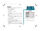
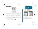
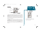
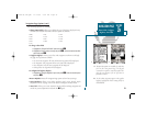
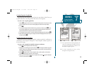
AB
A. Thirteen data options are available for each data
field on the Navigation Page. The digital
crosstrack error option is especially useful to dis-
play the exact distance you are off course in
feet/miles or meters.
B. To select what waypoints appear on the graphic
highway, highlight the desired setting and press
EDIT/ENTER.
19000138.10A.QXD 11/11/99 8:47 AM Page 51