


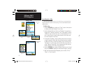

40
GPSmap 76CS
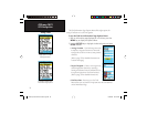
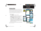
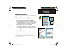
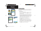
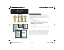
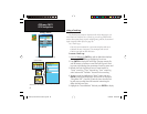
Searching for a Marine Point
The Find Marine Point feature allows you to search for the marine
Tide Prediction Stations provided in the marine basemap contained in
your GPSmap 76CS. When detailed marine map data has been down-
loaded from MapSource Marine Charts you can also view marine items
such as marinas, navaids, wrecks and obstructions.
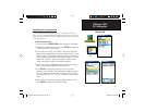
To find a Tide Prediction Station
1. Press the FIND button to display the Find Menu.
2. Select the Marine Points icon, then press ENTER to display the
sub-icon(s) for marine items supported by the basemap and
downloaded detailed marine charts.
3. Use the ROCKER key to highlight and select the Tide Station
icon, then press ENTER.
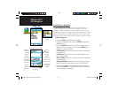
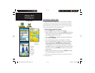
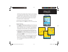
4. A list of tide stations nearest to you displays. If a “None
Found” message displays, then you are not currently located
near a coast line. Press the MENU key to display the Tide
Station Options Menu. Select from “Nearest Containing” or
“Change Reference.” You can enter a key word for a known
tide station or can use the map pointer to move to the nearest
coast line and then press ENTER to establish a location near
marine items.
5. Select a tide station from the list and press ENTER to display
the information page for that tide station.
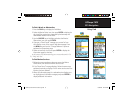
At the bottom of the Information Page are on-screen buttons for “Go
To,” “Map” and “Save.”
GPS Navigation
Using Find
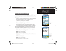
Tide Station List
Tide Station
Prediction
Page
(High and Low
tides for a 24
hour period
for the date
shown)
Tide Station
Symbols on
Map Page
GPSmap 76CS Owner's Guide copy.indd 40GPSmap 76CS Owner's Guide copy.indd 40 10/8/2004 8:27:53 AM10/8/2004 8:27:53 AM