


4
GPSmap 76CS
Getting Started
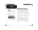
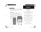
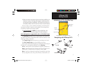
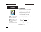
Satellite Page Acquiring Satellite Signals
Initialization & the Satellite Page
The GPSmap 76CS locates satellites above its position
Options
Menu
GPS Elevation
display
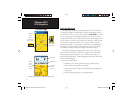
Starting Up the GPS Receiver
When you turn on the GPSmap 76CS, the GPS receiver begins to
search for satellites in order to determine (fi x) its location. This process
is called “initialization” and can take from 5 to 15 minutes the fi rst time
you use your unit. Thereafter, if you haven’t moved more than 600 miles
from your original location, it takes only seconds to minutes. In order to
receive satellite signals, you must be outdoors and have a clear view of
the sky. Satellite signals cannot pass through solid materials (except glass)
or dense overhead tree cover. To shorten the time required for initializa-
tion, select “New Location” from the options menu, then use the Map
Page to determine your general location
so the
GPSmap 76CS
can search
for those satellites above you.
T
o initialize your GPSmap 76CS:
1. Press and release the POWER key to turn on the unit.
2. Observe the “Power On” Page followed by the Satellite Page.
3. While the GPS receiver is searching for the satellite signals, a
“Locating Satellites” message is replaced by an “Acquiring
Satel-
lites” message until enough signals are acquired to fi x its location.
If the unit cannot get a satellite fi x, a list of solutions appears.
Highlight the appropriate solution and press ENTER.
You can also observe a sky view array of the satellites overhead with
your position centered in the array. The outer circle represents the hori-
zon and the inner circle a position 45
o
from the horizon. The numbers
displayed indicate the number assigned to each satellite. A bar graph at
the bottom of the page displays the strength of signals from each satellite.
Heading Bug
indicates
your direction
of movement.
GPSmap 76CS Owner's Guide copy.indd 4GPSmap 76CS Owner's Guide copy.indd 4 10/8/2004 8:26:33 AM10/8/2004 8:26:33 AM