


26
Reference
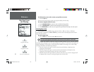
Map Page Cursor
and Zooming
To eliminate the cursor and re-center your position on-screen:
1. Press the QUIT key.
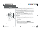
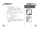
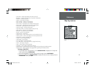
The cursor may also be used to create new waypoints directly from the map.
To create a waypoint with the cursor:
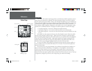
1. Use the ARROW KEYPAD to move the cursor to the desired map position.
2. Press the ENTER/MARK key and the New Map Waypoint Page will appear.
3. Press ENTER/MARK to confi rm the new waypoint using the default three-digit name and symbol.
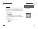
Selecting Map Scales
The map display has 24 available range scales from 120 ft. to 800 mi. (30 mt. to 1200 km).
The map scale is controlled by the IN and OUT keys, with the current scale displayed at the bottom
right of the data window.
To select a map scale:
1. Press the OUT key to zoom out and the IN key to zoom in.
The scale value represents the distance from one end of the scale bar to the other.
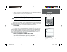
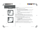
The GPSMAP 168 Sounder’s system has a built-in worldwide database to 20 mi, with more detailed
coverage available through the use of the optional MapSource software. The GPSMAP 168 Sounder will
display cartography as long as there is chart information available for the range you’ve selected. Map
coverage will conform to the following conditions:
• When the selected zoom range is covered by either the internal database or MapSource data,
cartography will be displayed.
• When the selected zoom range is covered by both the internal database and MapSource data,
cartography will be displayed using the data with the best resolution.
• When the selected zoom range exceeds the resolution of the data in use, overzoom cartography will
be displayed and an ‘overzoom’ warning will appear below the scale fi eld.
F
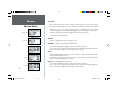
Using Built-In Basemap
Using MapSource Data
Overzoom, no additional data
Creating a New Map Waypoint
168 Manual Part 1.indd 01/09/01, 10:41 AM26