


5
CAUTION: The Global Positioning System (GPS) is operated by the government of the United
States, which is solely responsible for its accuracy and maintenance. The system is subject to changes
that could affect the accuracy and performance of all GPS equipment. Although the StreetPilot III is
a precision NAVigation AID (NAVAID), any NAVAID can be misused or misinterpreted and, therefore,
become unsafe.
MAP DATA INFORMATION: One of the goals of GARMIN is to provide customers with the
most complete and accurate cartography that is available to us at a reasonable cost. We use a combina-
tion of governmental and private data sources, which we identify as required in product literature
and copyright messages displayed to the consumer. Virtually all data sources contain inaccurate or
incomplete data to some degree. This is particularly true outside the United States, where complete and
accurate digital data is either not available or prohibitively expensive.
CAUTION: IT IS THE USER’S RESPONSIBILITY TO USE THIS PRODUCT PRUDENTLY. THIS
PRODUCT IS INTENDED TO BE USED ONLY AS A TRAVEL AID AND MUST NOT BE USED FOR
ANY PURPOSE REQUIRING PRECISE MEASUREMENT OF DIRECTION, DISTANCE, LOCATION,
OR TOPOGRAPHY. THIS PRODUCT SHOULD NOT BE USED TO DETERMINE GROUND PROXIM-
ITY FOR AIRCRAFT NAVIGATION.
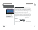
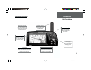
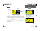
Because the map data may not be perfect, it will help
at times to cross-check the unit’s map with your actual
surroundings to confi rm that you are arriving at the exact
destination.
Map Data
Introduction
OM REV B.indd 6/28/01, 9:42 AM5