


dēzl 560 Owner’s Manual 29
Navigation
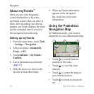
Public Transit Options
If you have cityXplorer maps
installed, the device calculates a
route that uses a combination of
public transit options, such as riding
a bus or subway, and walking.
cityXplorer maps are not included
with the device. See
http://my.garmin.com to purchase
cityXplorer maps.
The yellow icons indicate the
navigation method used in each
section of the route. For example,
when you see , board a bus at that
point in the route.
The black dots on the map are public
transit stops along your route.
NOTE: You can limit the distance
spent walking during a pedestrian
route (page 63).