


StreetPilot 2820 Owner’s Manual 41
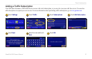
CUSTOMIZING THE STREETPILOT 2820
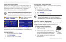
Selecting Units
From the Menu page, touch Settings > General > Units. Change
all units of measure to Statute or Metric. Custom allows you to
select metric or statue for a variety of units, such as distance, speed,
and temperature.
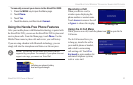
Turning Safe Mode Off and On
From the Menu page, touch Settings > General > Safe Mode.
Turn on or off Safe Mode, which disables all unit functions
that require significant operator attention and could become a
distraction while driving. For example, when Safe Mode is On, you
cannot search for a location while the vehicle is moving.
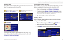
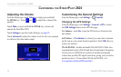
Changing the Coordinates Settings
From the Menu page, touch Settings > General > Coordinates.
Position Format—change the appearance of coordinates.Your
current position is viewed on the GPS in the form of coordinates.
Because different maps and charts use different position formats,
the StreetPilot 2820 allows you to choose the correct coordinate
system for the type of map you are using.
Map Datum—select the map datum to be used by your StreetPilot
2820. If you are navigating and comparing the GPS coordinates
to a map, chart, or other reference, set the map datum in your
StreetPilot 2820 to the same datum as the map to ensure the most
accurate navigation.
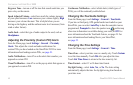
Changing the Map Settings
From the Menu page, touch Settings > Map.
Map Detail—adjust the amount of detail shown on the map. The
map redraws more slowly when detail is increased.
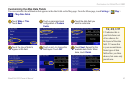
Orientation—change the perspective of the map.
• 2D North Up—display the map in two dimensions (2-D)
with North at the top of the screen.
• 2D Track Up—display the map in two dimensions (2-D)
with your direction of travel at the top of the screen.
• 3D Track Up—display the map in three dimensions (3-D)
with your direction of travel at the top of the screen. This is
the default map view.