


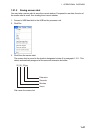
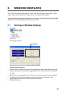

2. WINDOW DISPLAYS
2-5
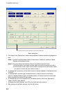
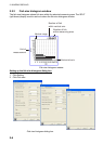
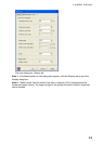
Data display description
Item Description
Picture
advance
Show current picture advance setting.
Shift Show current shift value.
Alarm Show current alarm content.
Gain Show current gain setting.
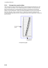
Timer
Choose Marker line from the menu bar and push the left button. The timer
then counts up the number of minutes (max. 99 min. 59 sec.) since the left
button was pushed.
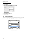
Temperature
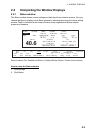
Water temperature data, fed from external temperature sensor, is shown.
Temperature range: -99.9°C to 99.9°C
L/L
Position data, fed from a navigator, is shown.
Latitude and longitude range:
Latitude: 90°00.000’S to 90°00.000’N
Longitude: 180°00.000’W to 180°00.000’E
Speed
Speed, fed from speed log, is shown.
Speed range: 0.0 kt to 99.9 kt
Course
Course, fed from a navigator, is shown.
Course range: 0°-359°
Roll
Roll angle, fed from appropriate sensor, is shown.
Roll angle range: -90.0° to 90.0°
Pitch
Pitch angle, fed from appropriate sensor, is shown.
Pitch angle range: -90.0° to 90.0°
Heave
Heave, fed from a satellite compass, is shown.
Heave range: -99.m to 99.0 m
Range/Bearing
Range and bearing to a TO waypoint, fed from a navigator, is shown.
Range and bearing: 0°-360°
Time
difference
Time difference, fed from a Loran C navigator, is shown
Time difference range: 00000.0 to 99999.9
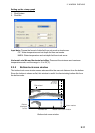
Draft Draft calibration method is shown; below surface or below transducer.