


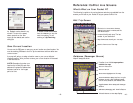

Helpful Hints
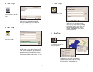
Installation
Your Product Key Code can be found on the cover of your printed Quick Start.
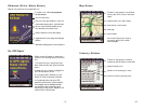
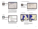
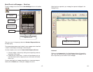
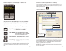
One-Touch Access to CoPilot
You can program one of the buttons on your Pocket PC for one-touch
access to CoPilot Live. Select Settings from the Start menu, click the
Buttons icon, highlight the button you would like to program by clicking
on it, and select CoPilot Live from the drop-down Button assignment: menu.
In future uses pressing the assigned button will immediately launch CoPilot.
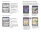
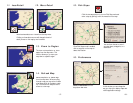
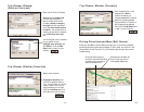
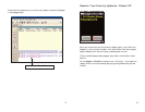
GPS Tracks
CoPilot Live will automatically track your trips and save them as .gps files on
your Pocket PC. You can play back a .gps track at any time to review a
previous route. To save memory space on your Pocket PC, you may want to
empty this folder occasionally and transfer the track files to your desktop PC’s
hard drive. To do this, follow these steps:
1) Connect your Pocket PC to your desktop using ActiveSync.
2) In the ActiveSync window, click Explore.
3) Open the GPS Tracks folder, and cut and paste the .gps files to a folder on
your desktop PC’s hard drive.
NOTE: These files are also helpful to us. Using your GPS tracks, we can
enhance the street-level system to provide even more accurate map data with
each new release. Occasionally, please take these files, zip them, and send
them to ccptrax@alk.com. Or open CoPilot on your desktop PC while your
Pocket PC is connected via ActiveSync, then select E-mail tracks to Club CoPilot
from the GPS menu in CoPilot on your desktop.
About GPS Technology
The Global Positioning System (GPS), developed by the U.S. Department
of Defense, is a constellation of 24 satellites that orbit the Earth twice daily.
Each satellite contains an atomic clock that is accurate to the nanosecond, and
constantly emitting radio waves toward Earth. GPS sensors (hardware devices
for receiving data) can receive these signals from the satellites, and using their
own internal clock can calculate the amount of time it has taken for the signal to
be received. GPS relies on the fact that radio waves travel at the speed of light
to calculate distances, and the exact location of the sensor is figured by
combining the data received from four satellites. Using the data from these
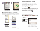
How CoPilot Live Uses GPS
CoPilot Live uses the GPS positional data that it receives from the hardware unit
you place on your dashboard to display your current position on a map as you
drive. This is called "tracking". CoPilot also uses the GPS data it receives to
guide you along your planned route, provided you enter a destination on your
Pocket PC. CoPilot Live guides you with audible prompts as you drive as well as
on-screen directions.
Tracking will begin automatically when you have satellite reception. In order to
get route guidance you have to enter a destination on your Pocket PC. Tracking
may also be used without receiving guidance instructions when you’re in
Navigating Mode. In this case, you'll see your trip tracked on the map on your
Pocket PC as you drive, but you won't see a highlighted route on the map and
you won't be given driving directions.
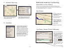
GPS Accuracy
The GPS signal CoPilot Live receives from the constellation of satellites
has a rated accuracy of within 5 - 10 meters. This means that 95% of the time
the reported location is within 15 - 30 feet of your exact position. CoPilot takes
this location information and enhances it further by "snapping" it to our street
and highway network. Occasionally, CoPilot will place you on the wrong road. If
this occurs, keep driving and CoPilot will automatically correct itself and find your
proper position.
At times, CoPilot Live's GPS tracking will be less accurate or fail to work at all
because the unit is unable to receive satellite signals. Heavy foliage, tall buildings,
or any other structures obstructing communications will interfere with CoPilot's
ability to track your location. Like your car radio, GPS tracking can also be affect-
ed by weather conditions if severe. CoPilot Live will continue tracking as soon as
adequate signals are available. Despite these limitations, you can expect CoPilot
Live to provide you with useable and accurate information most of the time.
CoPilot Live will alert you if accurate information is unavailable.
- 73 - - 74 -
four satellites, GPS is able to give you the latitude, longitude and elevation of
your present location, and also your road speed and direction of travel on a
route. Given the right conditions, a GPS sensor can identify your geographic
position anywhere in the world within a matter of a few meters.