


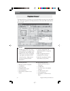

68 Magellan MAP 330 GPS Receiver
Appendix
Appendix
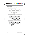
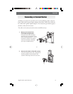
Navaids. Included with the MAP 330M are fixed navaids (lights), buoys,
lighthouses, marinas and obstructions (wrecks, rocks, etc.). These
navaids can be accessed through the database in the same manner that
any other waypoint or map object can be accessed using the Database
function.
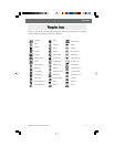
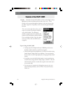
The screen to the right shows what you can
expect to see when accessing the database
with a MAP 330M. The additional
database categories have been added to the
bottom of the list following National Parks.
If you scroll down further, using the down
arrow, you will see the rest of the navaid
categories.
Tips on Using the MAP 330M
• Loading maps from MapSend Streets CDROM provides more
detailed coastlines which are useful for navigation.
• Navaid icons begin being displayed at 3.5 mile scale with the Map
Detail (found in Map Setup) set to Medium. You can adjust the
density of the navaids being displayed by changing the Map Detail
setting.
• If you plan to use the MAP 330M mostly in marine applications,
set the Primary Usage (found in Map Setup) to Marine. This will
make the boat’s position, navaids and waypoint icons much easier
to see on the map.
• You may want to customize the Navigation screens to give you
marine-related parameters, such as XTE, CTS (course to steer),
VMG, etc.