


29Magellan MAP 330 GPS Receiver
Reference
Reference
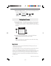
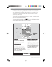
When Nav Info is hidden and the map is in the cursor mode, the
bearing (BRG) and distance (DIS) to the cursor is shown at the bottom
of the map. If the cursor happens to be on a map object, the name of
the object is displayed instead of BRG/DIS.
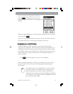
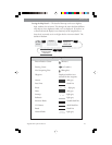
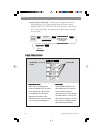
Selecting Street Information or Data Fields for Nav Information —
When the Nav Info box is being displayed at the bottom of the Map
screen, you have the option of displaying street information or two
customizable data fields. Note: This option is available only if the Nav
Information is being displayed. (See Turning Nav Info On/Off.)
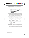
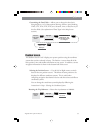
From
Map
Screen
MENU
ENTER
Highlight
Customize
ENTER
Highlight
Street info
or
Two nav fields
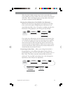
If you select Street Information, the Nav Info box at the bottom of the
screen displays the name of the street or intersection you are travelling
on. As you are travelling on a street, the name of that street will be
shown on the first line of the Nav Info box and the name of the next
cross street is shown on the second line. When you are not on a street,
the Street Information will be replaced by the two data fields until it is
determined that you are back on a street.
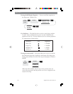
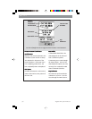
Customizing the Data Fields — Allows you to change the data that is
being displayed to 1 of 13 different data options (bearing, distance,
speed, heading, VMG, CTS, ETA, ETE, XTE, turn, elevation, time, or
date). Note: To be able to customize the data fields, you must be
viewing the “Two nav fields” on the Map screen. (See Selecting Street
Information or Data Fields for Nav Information.)
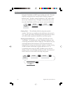
From
the MAP
Screen
MENU
ENTER
ENTER
ENTER
Highlight
Customize
Use L/R arrows to
highlight the title
for the data field to
be changed
Use arrows to
select new
data type
Highlight
Two nav fields
ENTER