


27Magellan MAP 330 GPS Receiver
Reference
Reference
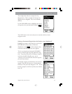
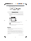
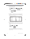
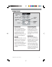
Setting the Map Detail — The detail of the map can be set to highest,
high, medium, low or lowest. This changes the zoom level that different
map objects (cities, highways, labels, etc.) are displayed. If you have set
a zoom level and the display is too cluttered, set the map detail to a
lower level; conversely set it to a higher level to view more detail. The
default is Medium.
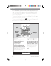
From
the MAP
Screen
MENU
ENTER
ENTER
NAV
ENTER
Highlight
Map Setup
Use arrows to
highlight the
“Detail” field
Use arrows to select
the desired Map
Detail level
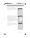
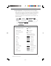
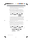
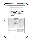
Map Screen Legend
Present Position Cursor (Pointer )
Panning Cursor (Crosshair )
Not Computing Fixes (Hourglass)
Waypoint Displayed with the icon
selected for that waypoint.
Oceans - dark gray
State Lines - black line
Rivers - light gray
Lakes - dark gray
Swamps - light gray
Railroads - light gray
Interstate Roads - double black line
U.S. Routes - thick black line
Roads - black line
National Parks - light gray