


32 Magellan MAP 330 GPS Receiver
Reference
Reference
Setting the Track Mode to “OFF” stops recording your track. The same
temporary waypoints used to create the track are used to compute a
backtrack route. Therefore, setting Track Mode to “Off” will not allow
you to create a backtrack route. It is highly recommended that you do
not set the Track Mode to OFF in case you ever need to use backtrack.
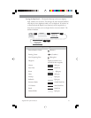
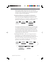
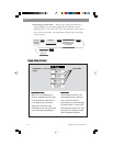
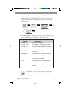
From
the MAP
Screen
MENU
ENTERENTER
Highlight
Clear Track
Confirm
Clearing Track — This will delete all of the track points stored in
memory. This is how you would reset the track history at the start of a
trip. Use this with caution. By deleting the track points that are stored,
you will be unable to perform a backtrack to any of these points.
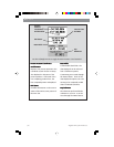
Selecting Land or Marine Use — As a default, the MAP 330 is in the
“Land Mode.” In the land mode, water is displayed as dark grey areas
on the map and and land is shown in light grey. This makes it very easy
to distingish between land and marine areas and provides the best
background for viewing street information. However, it makes viewing
navaids and other marine-based waypoints difficult to view. To
accommodate marine usage, the MAP 330 allows you to switch the
shading to make water areas light and land areas dark. The selection of
land or marine use can be found in the Map Setup option.
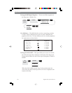
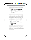
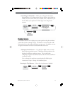
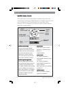
From
the MAP
Screen
MENU
ENTERENTER
Highlight
Map Setup
Use U/D arrows to
select Marine or
Land.
Highlight
Primary Usage
ENTER