


38 Magellan MAP 330 GPS Receiver
Reference
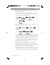
Reference
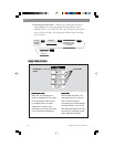
Satellite
Position
Satellite
Position Graph
Battery Life
Indicator
Satellite Signal
Strength Chart
Power
Source
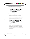
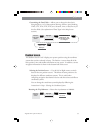
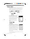
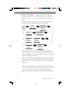
Satellite Position GraphSatellite Position Graph
Satellite Position GraphSatellite Position Graph
Satellite Position Graph
The two circles indicate satellite
elevation as seen from your current
position; the outer circle represents
the horizon and the inner circle
represents 45° from the horizon.
The center of the circle is 90° from
the horizon, or directly overhead.
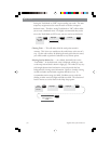
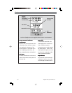
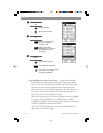
Satellite Signal Strength ChartSatellite Signal Strength Chart
Satellite Signal Strength ChartSatellite Signal Strength Chart
Satellite Signal Strength Chart
Displays satellite signal strengths.
Clear bar indicates that the MAP 330
is starting to get information from
the satellite. Satellites that are being
used to compute your position are
shown with solid bars. The height of
the bar indicates the relative signal
strength; the higher the bar, the
stronger the signal.
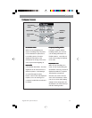
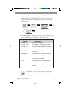
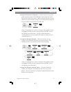
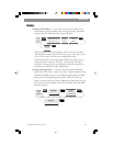
Power SourcePower Source
Power SourcePower Source
Power Source
Indicates the source of power
being used — POWER (Internal
Battery) or
POWER EXTERNAL.
Position ModePosition Mode
Position ModePosition Mode
Position Mode
3D - position computed is
3-dimensional (elevation is being
computed).
2D - position computed is
2-dimensional (elevation is not
being computed).
Blank - MAP 330 is not computing
a position fix.
Satellite PositionSatellite Position
Satellite PositionSatellite Position
Satellite Position
Where the satellite is located
relative to your position.
Position
Mode
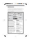
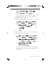
The Satellite Status screen visually displays the satellites being used and the
strength of the received signal. Additionally, this screen displays the power source
you are connected to and, if internal batteries, how much battery life is
remaining. This is a very handy screen when you wish to view how well your
MAP 330 is tracking satellites.