


47
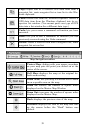
NOTE:
You can always use the Zoom-In or Zoom-Out buttons, no matter
what other commands may be activated.
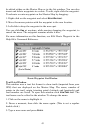
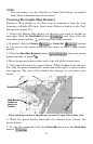
Creating Rectangle Map Borders
Making a Map Border is the first step in creating a map for your
Lowrance or Eagle GPS unit. Here's how: (Refer as needed to the Tool-
bar section on page 35.)
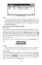
1. Center the Master Map display on the area you want to include in
your map. Click the
CENTER MAP button , and then click the
cross-hair mouse pointer on the area you want centered.
2. If needed, click the
ZOOM IN or ZOOM OUT buttons
so you can see the entire area that you want to draw a map border
around.
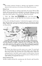
3. Click the
DRAW MAP BORDERS button , and your mouse
pointer becomes a pencil.
4. Move the mouse pointer above and to the left of the desired area.
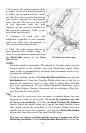
5. Click and hold down the mouse button. While holding down the but-
ton, drag the pointer diagonally, down and to the right. A green border
box appears. The size of the border box changes as you move your
mouse.
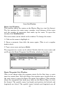
Click and drag to draw a Map Border around Corpus Christi Bay area.
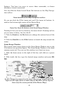
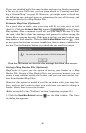
6. When the green border surrounds the desired area, release the
mouse button.
7. To stop the command, click the
CENTER MAP button or the ZOOM AREA
button.
Map Border
shown in
green on
screen.
Handle Box
Mouse Pointer