


22 Oregon Series Owner’s Manual
Additional Tools
• —view the
predicted best dates and times
for hunting and shing at your
current location.
• —use a timer, mark
a lap, and time laps.
• —mark a
man overboard position and
start navigation. Follow the
on-screen instructions.
• —rene
a waypoint location with
multiple samples to achieve
the most-accurate location
possible. Follow the on-
screen instructions. For more
information, refer to Trail Tech
at www.garmin.com.
• —point the unit
toward an object to lock in
the direction and navigate
to it. Follow the on-screen
instructions.
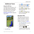
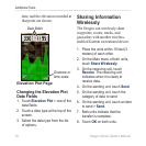
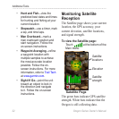
The Satellite page shows your current
location, the GPS accuracy, your
current elevation, satellite locations,
and signal strength.
Touch at the bottom of the
Main menu.
Satellite
locations
Elevation
Satellite
strength
The green bars indicate GPS satellite
strength. White bars indicate that the
Oregon is still collecting data.